
Hurricane Laura intensified into a potent storm over Tuesday night — and then continued strengthening. The large cyclone packed 140 mph winds as of Wednesday afternoon.
Now officially a major Category 4 hurricane, Laura is expected to pummel parts of the Gulf Coast in east Texas and western Louisiana before traveling inland. The National Hurricane Center predicts Laura may strengthen even more before making landfall late Wednesday or early Thursday. It could be the most powerful storm to hit Louisiana in over a century.
“Laura has become a very powerful hurricane,” the National Hurricane Center wrote Wednesday. “Even if the rate of strengthening eases, Laura is expected to be an extremely powerful category 4 hurricane when it reaches the northwestern Gulf coast.”
The agency warned of “Catastrophic Storm Surge, Extreme Winds, and Flash Flooding Expected Along the Northwest Gulf Coast Tonight.”
Warm ocean waters are hurricane fuel, and the Gulf of Mexico is notoriously warm this time of year (with temperatures well above 80 degrees Fahrenheit), while some areas of the gulf are even warmer than usual. Warmer oceans fuel tropical storms as more water naturally evaporates into the air, giving storms energy and moisture to intensify. (Storms convert this evaporated water to water droplets and ice particles, which releases energy.)
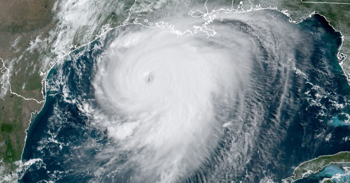
Hurricane Laura has developed all the signs of a well-organized, robust storm, including the formation of a clear, telltale eye.
“I should be sleeping but impossible when this is happening with #Laura,” Eric Blake, a senior hurricane specialist at the National Hurricane Center, tweeted Wednesday morning. “Look at the eye starting to get warm and clear out on this satellite loop. Classic signature of a powerful hurricane getting stronger- just horrible to see it so close to the coast.”
“This is not an image you ever want to see,” tweeted disaster researcher Samantha Montano, referencing a satellite loop of Laura growing stronger.
Take a look:
Laura’s storm surge, caused by winds forcing ocean water inland, will be extreme. The National Hurricane Center expects “Unsurvivable storm surge with large and destructive waves,” with water reaching 15 to 20 feet high in some places. On the flat coastal plains, seas could travel some 30 miles inland.
Beyond winds and storm surge, Laura will deluge inland areas, triggering flash flooding over a vast region.
Hurricane researchers have expected a strong hurricane season for months, in large part thanks to warmer-than-normal ocean temperatures. In early August, the National Hurricane Center bumped up its prediction to “an extremely active” Atlantic hurricane season, an escalation from “above normal.”
In the coming years and decades as the planet and oceans relentlessly warm, hurricane researchers don’t predict more hurricanes overall, but expect them to grow more intense, like Laura. This means higher wind speeds and more Category 4 and 5 storms. “We think there will be an uptick in the most intense storms,” Brian Tang, an atmospheric scientist at the University of Albany, told Mashable in July.