A seafaring drone can sail where people can’t: straight into a hurricane.
During the 2021 Atlantic hurricane season (it’s predicted to be busy), that’s exactly what scientists will do: send marine robots into the heart of churning cyclones. The unprecedented mission aims to improve researchers’ understanding of how hurricanes rapidly intensify into monstrous storms with destructive winds and deadly flooding. If all goes as planned, the drones will venture through the storm’s most violent winds, which circle the eye of a cyclone, called an eyewall.
“We want to go straight through — we want to go through the eyewall,” said Gregory Foltz, a National Oceanic and Atmospheric Administration (NOAA) oceanographer who’s working on the mission.
It’s a collaborative endeavor between NOAA and Saildrone, the company that engineers the innovative sailing drones.

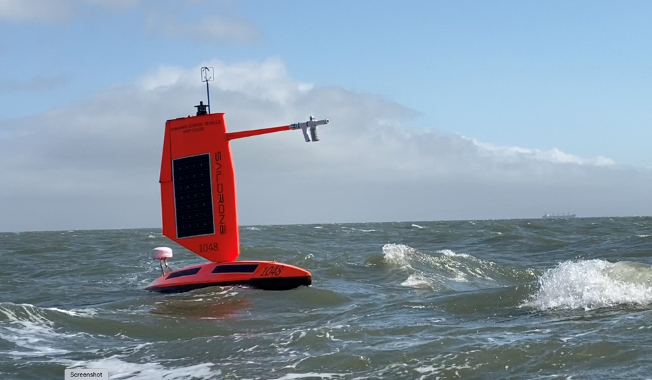
A Saildrone tested in the choppy San Francisco Bay.
Image: saildrone
Five drones will be staged in the Atlantic basin in August; three in the Caribbean and two near the U.S. East Coast. When inevitable hurricanes form this summer and fall, scientists will unleash the uncrewed vehicles, designed to withstand pummeling winds, into the path of the storms.
“We’re confident we can send the vehicles into hurricanes,” explained Richard Jenkins, Saildrone’s founder.
Jenkins isn’t worried about extreme winds (which in stronger hurricanes exceed some 110 mph). The seaworthy drones, which have already proven themselves in the tempestuous Southern Ocean, can withstand severe conditions. This latest version of Saildrone, a 23-foot-long robot with a lower profile to brave intense winds, are specifically designed for hurricanes. Still, walls of crashing whitewater, spawned during some storms, might potentially damage the sails (or “wings”). Yet that’s part of the pilot project — to see what works, and how to improve.
“It will be a voyage of discovery,” said Jenkins. “We’re going to break things and we’re going to learn.”
“We’re going to break things and we’re going to learn.”
NOAA is interested in the Saildrones because they’ve proven excellent at directly gathering observations of ocean and atmospheric conditions on the sea surface. It’s there, where the oceans interact with the air, that hurricanes start to strengthen, sometimes rapidly. Warm ocean waters, at 80 degrees Fahrenheit or above, fuel hurricanes, as the storms suck up evaporated seawater. This ultimately provides storms the energy and moisture they need to strengthen.
The Saildrones will focus on how the ocean transfers heat and energy to storms, explained NOAA’s Foltz. “We’ll learn a lot,” he said.
Of particular interest to storm researchers like Foltz are the conditions that stoke tropical cyclones to “rapidly intensify,” meaning a storm’s winds increase by at least 35 mph in a 24-hour period. For communities, stronger storms bode more destructive winds and higher coastal storm surges — dangers everyone in them would benefit from knowing about.
In recent decades, hurricanes have rapidly intensified more often. That’s likely because hurricanes feed on warmer waters, and the oceans are warming as Earth’s climate warms. “The frequency of rapid-intensification events has increased over the past four decades, and this increase has been linked to climate change,” Jim Kossin, an atmospheric research scientist at NOAA, explained in an agency Q&A last year.
As the surface temperatures of oceans warm, hurricane scientists don’t expect more hurricanes overall, but expect storms to grow more powerful (though certainly not always). Already, the frequency of strong Atlantic storms (Category 3 or higher) have increased since 1979.
SEE ALSO: Why it’s impossible to forecast the weather too far into the future
While hurricane tracking (where the storms will go) has improved markedly in recent decades, predicting storm intensities has proven more challenging. There are so many nuances and evolving factors transpiring between the ocean and the atmosphere that impact intensity, explained NOAA’s Foltz. Many unknowns remain. But Saildrone’s observations — if this pilot mission proves successful and sustainable — might better reveal what’s driving intensification in these storms.
The drones also have cameras, so we may soon see unprecedented footage of the stormy seas beneath the largest storms on Earth. “It’ll be exciting to see from the safety of your armchair,” noted Jenkins.