
The Atlantic keeps breaking records.
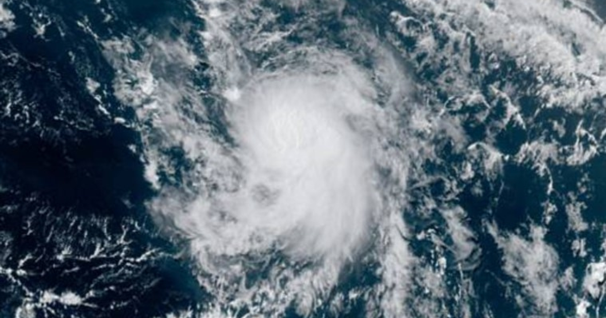
Tropical Storm Gonzalo formed in the Atlantic Ocean on Wednesday, the earliest time on record for the seventh named storm of the season to form (a tropical storm, which earns a name, has wind speeds of at least 39 mph). The Atlantic’s seventh named storm doesn’t usually occur until around September 16. The earliest third, fifth, and sixth storms also formed in 2020, though none reached hurricane intensity.
The major storm culprit this year has been warmer than usual sea surface temperatures of over 80 degrees Fahrenheit. Warmer oceans fuel tropical storms as more water naturally evaporates into the air, giving storms energy and moisture to intensify.
“It’s certainly been active,” said Brian Tang, an atmospheric scientist at the University of Albany. “Ocean temperatures in the Atlantic are running much warmer than normal.”
Though these early 2020 Atlantic storms have been relatively weak, warmer ocean temperatures may provide ample fuel for the approaching peak of hurricane season.
Of note, temperatures in a critical zone of the Atlantic called the “Main Development Region,” extending from the African coast to the Caribbean Sea, are about 1 degree Fahrenheit warmer than average — which is a big deal. Most hurricanes form in this region during the most active part of hurricane season, which lasts from about mid-August through mid- to late- October. During this time, clusters of thunderstorms from Africa travel over the Atlantic, and their destiny largely rests on water temperatures.
“That extra degree makes it more likely the thunderstorms will survive going across the Atlantic,” said Chris Slocum, a research meteorologist at the NOAA Center for Satellite Applications and Research. As they pass over warm waters, these storm systems can mature into rotating, powerful hurricanes.
Unlike the earlier Atlantic storms this year, Gonzalo formed in the deep tropics where big storms are made. It shows this critical hurricane region is primed for storm activity. “Typically, when you get tropical cyclone formation in the deep tropics prior to August 1, it’s a sign of a very active season,” said Philip Klotzbach, a hurricane researcher at Colorado State University.
Not to beat a dead horse but, the Atlantic Main Development Region is exceptionally warm atm. Here’s a plot of the OISSTv2.1 SSTa percentiles for the week ending July 20th.
Grid points that exceed the 95th percentile (within the top 3 ranks) are contoured in white#Tropics
🔥🔥 pic.twitter.com/p8n2sG2TeJ— Eric Webb (@webberweather) July 22, 2020
Yet, warmer Atlantic temperatures don’t guarantee big hurricanes or a large number of storms. Other factors can derail storms. In the coming months, hurricane researchers will watch for dry regions of air (which stifle moisture-hungry storms), strong winds blasting from the West (which tear apart hurricanes), and generally any winds that might consistently blow over and cool the ocean surface like a fan.
“Going into August, September, and October those factors will be critical,” said Tang.
Importantly, even if this Atlantic storm season flops — even though it’s looking strong — the season can still be devastating. In 1992, Hurricane Andrew slammed into Florida, leaving some 250,000 people temporarily homeless. At the time, Andrew was the costliest natural disaster in U.S. history.
“It was a very inactive year,” said NOAA’s Slocum. “But Hurricane Andrew made landfall in Miami. It only takes one storm.”
“It only takes one storm.”
Overall, the oceans globally are now absorbing almost unfathomable amounts of heat each year as the planet relentlessly warms. Yet, how this major ocean heating will influence future storm activity is a hot area of atmospheric research. Future storms are a complicated mix of an atmosphere and ocean that are both interacting and changing.
For now, Tang notes hurricane researchers have the most confidence about these future trends:
It’s likely that Gonzalo, the earliest formed seventh named storm on record, will intensify into a hurricane as it picks up steam while traveling just above South America. Hurricane scientists already have their eyes on other areas of the Atlantic that are ripe for storm activity in the coming weeks, too.
“The Atlantic is coming alive,” said Tang.