Even though California is setting record high temperatures this Labor Day weekend, autumn is mere weeks away. It might not feel like fall yet, but the changing foliage is definitely coming. And we have a digital map to prove it.
The 2020 Fall Foliage Prediction Map from SmokyMountains.com is finally live, which means you can officially start planning your outdoor fall activities and scenic road trips.
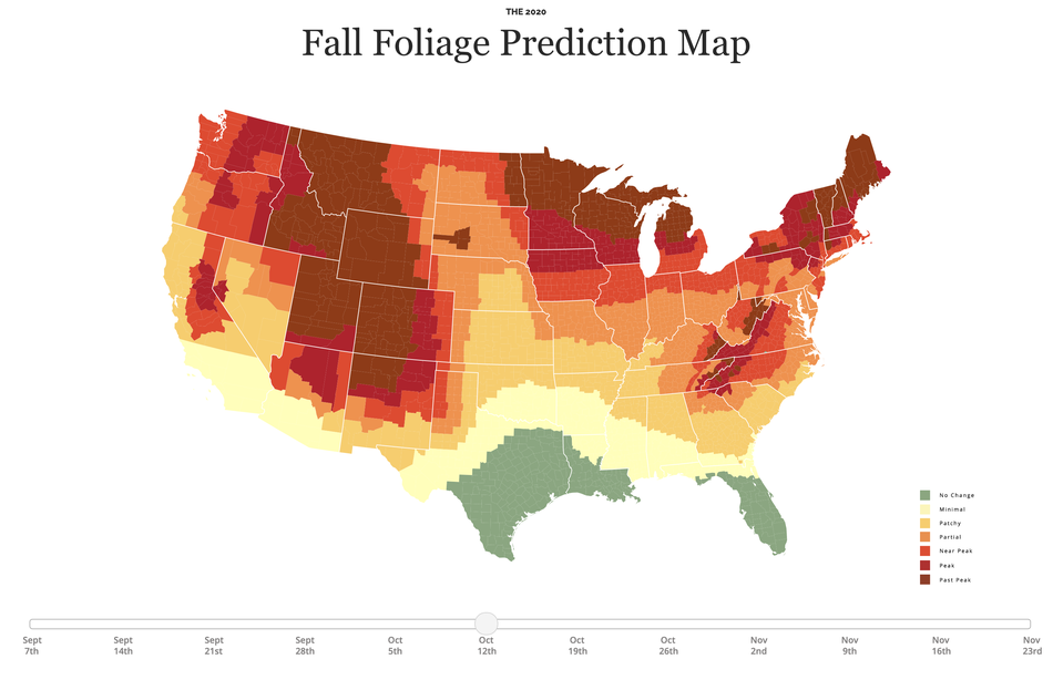
If you’ve never used the annual interactive tool before, you’re in for a real treat. This year’s map begins on Sept. 7, a day when minimal and patchy foliage is predicted in only a few states. The map concludes on Nov. 23, when nearly the entire country will be be past-peak foliage.

By using a data-driven algorithm, the map analyzes temperature and precipitation records from the National Oceanic and Atmospheric Administration, along with past leaf peak trends, to predict what foliage will look like across the U.S. in September, October, and November.
Though the map won’t be 100 percent accurate, the tool does offer some great visual insight into the season.
“The map should be especially useful to potential travelers, leaf peepers, and photographers as they pick future dates for trips to view peak fall in each area of the United States,” Smoky Mountains founder and statistical expert David Angotti said in a statement. “The date picker, which can be found at the bottom of the map, helps the user visualize how fall will progress for both specific destinations and the entire country.”
To use the map, simply scroll to a desired date on the colorful bar below and watch the states change shades. Then, check the foliage of different locations using the key on the side of the map to determine how intense your leaves will look.
You can learn more about the map and the science behind fall foliage on SmokeyMountains.com.