
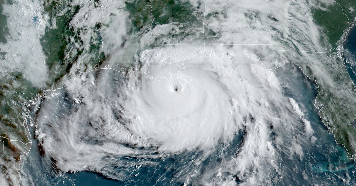
Hurricane Ida is about to pummel Louisiana as an “extremely dangerous” storm after strengthening rapidly over the weekend. The hurricane is swirling towards the coast with winds of 150 miles per hour, accompanied by a life-threatening surge of water, forecasters with the National Hurricane Center warned on Sunday.
“This will be one of the strongest hurricanes to hit anywhere in Louisiana since at least the 1850s,” Louisiana Governor John Bel Edwards said at a press conference on Saturday.
Ida already had wind speeds of 103 miles per hour on Saturday night. Just six hours later, the storm had strengthened into a major hurricane with wind speeds increasing to 130 miles per hour.
The storm was able to intensify so quickly because it had all the ingredients a hurricane needs to grow. Warm waters below the hurricane and moisture in the atmosphere provided fuel for the storm, while winds in the upper atmosphere favored the hurricane, allowing it to keep developing.
Rapidly intensifying hurricanes have developed many times in the past few years, including Harvey in 2017, and Michael in 2018. This rapid intensification may be caused in part by climate change, recent studies suggest. A recent United Nations report also found that storms are becoming stronger as the planet warms. Other factors, including cyclical changes in the ocean and atmosphere, may also play a role in rapid intensification — researchers are actively gathering more data about how the process works so that they can better predict when storms like Ida are likely to develop.
Ida is expected to make landfall in Louisiana on Sunday evening, on the 16th anniversary of Hurricane Katrina hitting the state. Hurricanes are categorized by wind speed, and Ida, currently a Category 4, is expected to bring catastrophic winds to the region. Along with the winds will come a storm surge, a huge pileup of water driven inland by the storm. If the storm makes landfall at high tide, forecasters expect waters to reach heights of 12-16 feet in parts of Louisiana. Ida will also dump 10-18 inches of rainfall on the region, and some areas could see as much as two feet of rainfall, with the potential for more flooding.
On Saturday, the National Weather Service office in New Orleans issued a dire warning to residents in its forecast discussion that underscores the seriousness of the storm:
These are the last few hours to prepare or leave. Conditions are expected to deteriorate late tonight and especially tomorrow morning. Once sustained tropical storm force winds move in first responders will button down and YOU WILL BE ON YOUR OWN. Please understand this, there is the possibility that conditions could be unlivable along the coast for some time and areas around New Orleans and Baton Rouge could be without power for weeks. We have all seen the destruction and pain caused by Harvey, Michael, and Laura. Anticipate devastation on this level and if it doesn`t happen then we should all count our blessings…Do not play around and say “I`ve been through Andrew/Camille/Katrina/Betsy” all storms are different.