There were some familiar features on display when the new version of Apple Maps was announced at this year’s Worldwide Developers Conference. Anyone who’s used its main competitor (ahem, Google Maps) knows where the iPhone-maker got its inspiration.
Apple Maps, especially the iPhone app version, will get a big overhaul with iOS 15’s release this fall. The new look for Maps first debuted last year with iOS 14 and is now expanding from the U.S., UK, Ireland, and Canada to Spain, Portugal, and Gibraltar. Later this year the new map will be in Australia and Italy.
There’ll be more information in more places with clearer bike lanes and pedestrian crossings along with new labels and markings for different elevations and ocean features, augmented reality walking directions in a few cities for iPhone users, super high-res 3D graphics in select cities, and better trip planning for driving and transit.
The things is, a lot of these improvements come after the Google Maps app has offered them to Android and iPhone users — sometimes for years.
The iOS 15 features Google Maps users will recognize
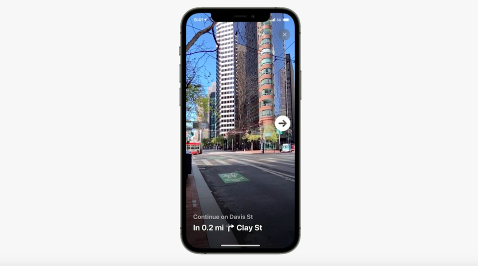
AR walking directions
In the fall, you’ll be able to add a layer of augmented reality with arrows and guidance when you hold up your phone in walking mode on Apple Maps. This will only be available in the San Francisco Bay Area, Los Angeles, New York, and London by the end of the year.

AR walking directions in San Francisco.
Image: apple / screenshot
Google added this to its maps app back in 2019. Just like with Apple’s version, it uses the camera to identify where you are and then adds a layer onto your screen to show where you should walk or which street you’re on. Google calls it “Live View,” and has been updating it over the years. Earlier this year Live View was available indoors in some places for navigating through, say, a shopping mall or airport.
More transit info

More transit options will be viewable.
Image: apple
Apple is giving more screen time to bus routes in the new operating system. Train and subway systems were more prominent but soon major bus lines (or your favorite or most used lines) will be displayed.
This isn’t an exact copy of a Google Maps feature, but Google’s transit info has been more robust compared to Apple’s for years. Bus schedules, estimated arrival times, and bus stops have always been baked into Google Maps’ transit section. Apple Maps is catching up.
More details
Apple is making its streets really pop for drivers, cyclists, and pedestrians. Things like bike lanes, medians, and crosswalks will be clearly visible and marked.
This level of detail in urban areas was added to Google Maps last year. Beyond city views, there were new details, colors and dimensions added on Google Maps for bodies of water and different elevations, like on Mount Kilimanjaro or the Mariana Trench in the Pacific Ocean. That same level of detail will now be on Apple Maps and its new globe, as seen above on a Mac desktop.
Route planning
Traffic projections have been Google Maps’ bread-and-butter for years. Now Apple is catching up with a new option to select the time you’re leaving for your drive or transit trip. You can also add when you’d like to arrive and the map will calculate the best time to leave. Sound familiar? You used to only get an estimate based on traffic conditions at that moment.
Unique new features on Apple Maps
It wasn’t all heavy lifting from a certain maps rival. Apple added and changed some features all on its own.
New icon
The Maps icon has a subtle new look. To align with its more detailed view of roads and terrain, Apple’s made the colors pop and rounded the edges a bit more. The 280 freeway sign is no longer on the icon, losing a bit of Apple history (Interstate 280 is the freeway that runs through Apple headquarters in Cupertino, California).

A new Apple Maps icon.
Image: apple / screenshot
Night view
In places like SF, LA, New York, London, San Diego, Philadelphia, and Washington, D.C., zooming in on cities will bring up a realistic 3D experience. But even cooler is the night mode view.
Major landmarks, like the Palace of Fine Arts in San Francisco, will be backlit and pop out from the dark background.

A lovely nighttime view.
Image: apple / screenshot
3D driving graphics
In driving mode, Apple’s 3D renderings make it easier to know where you’re going. At highway interchanges, the multi-dimension view lets you know exactly which part of the road you’re on and where to keep driving.

You’re less likely to miss that turn.
The super-detailed map mode won’t be available on Apple CarPlay right at launch, but later this year the 3D driving experience will show up on the car screen. So it’ll look like you’re driving across a kind of realistic version of the Golden Gate Bridge.

Not the real thing, but almost.
Image: apple
One-handed layout
In transit mode, information will be all be within one hand’s reach toward the bottom of the screen for when you’re holding onto a bus strap or bracing against subway door handles and only have one hand free. This seems like the type of feature a consumer tech company thinks about — and may explain why Google (a search engine company) doesn’t have a transit mode layout like that.
During the WWDC presentation, Apple emphasized how much it prioritizes security. So maybe it’s time to copy one more Google Maps feature: incognito mode.