You only have to switch to Satellite View on Google Maps to see how beautiful Earth looks from up high, but images from spacecraft capturing data in the near-infrared channel also create images of stunning beauty.
Take this one (below) captured earlier this year by the Copernicus Sentinel-2 mission and shared a few days ago by the European Space Agency.
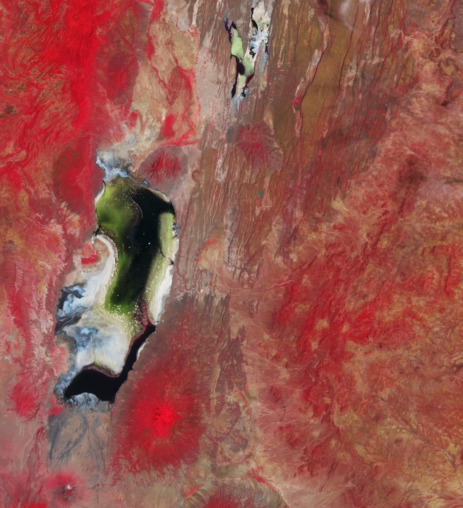
It shows the waters of two salty lakes in East Africa: Lake Natron in northern Tanzania and Lake Magadi in southern Kenya.
The vivid colors are down to the image processing via Sentinel-2’s near-infrared channel, which helps to reveal different information than what you’d find in a natural-color image.
“While heavy shades of red highlight vegetated areas and dominate this false-color image, the seasonal flowering of algae in the lakes appears green,” ESA explains. “The bright white and blue areas along the shores depict a mixture of sand, salt, and mud flats. Salt crusts, resulting from evaporation caused by high temperatures, can be spotted as white dots speckling the waters.”
At 34.8 miles (56 kilometers) long, Lake Natron is the larger of the two lakes and has a depth of just 9.8 feet (3 meters). It’s recognized as a wetland of international importance as it’s the only regular breeding area for lesser flamingos in East Africa, with as many as 2.5 million of them flocking to the area.
The smaller Lake Magadi, seen at the centre top of the image, is located in a vast depression in an area of volcanic rock. Like Natron, Magadi features a high salt content, which in some places is up to 131 feet (40 meters) thick.
Sentinel-2 is a two-satellite mission supplying the coverage and data delivery for Europe’s Copernicus Programme, an ambitious endeavor that brings together huge amounts of information gathered from environmental satellites, as well as air and ground stations and sensors, to build a comprehensive understanding of Earth’s health.
If you’d like to enjoy more Earth images taken from orbiting spacecraft, then check out these beautiful natural-color shots captured by French astronaut Thomas Pesquet during a stay at the International Space Station two years ago.
Editors’ Recommendations
Services Marketplace – Listings, Bookings & Reviews