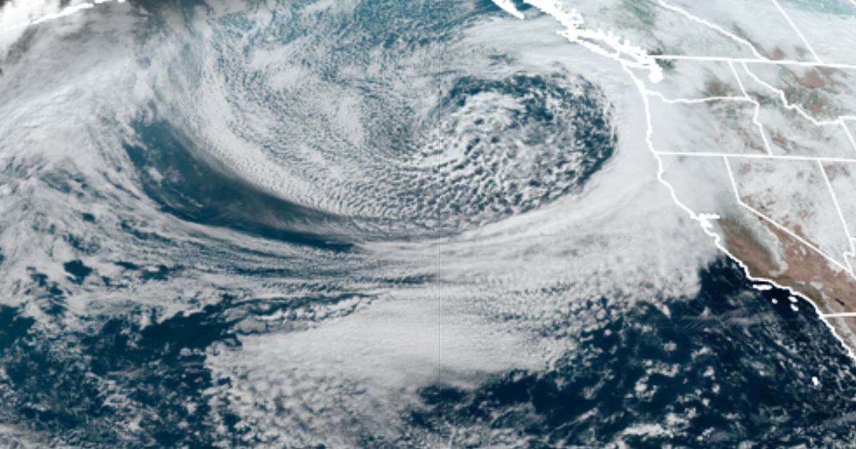
A potent, comma-shaped storm has moved over a large swath of California, promising to deluge regions in hazardous rains and thick snow.
It’s a mid-latitude cyclone, which is generally a counterclockwise spinning mass of air in this part (latitude) of the world. And it’s an impressively wet storm: The system has tapped into ample moisture over the Pacific Ocean, allowing the storm to dump thick bands of precipitation over the central and northern parts of the Golden State.
These types of intense streams or bands of moisture, carried by storms, are called “atmospheric rivers,” but this atmospheric river is somewhat unique. The storm is coming from the frigid north, as opposed to streaming across the tropical Pacific from around Hawaii (a more common weather phenomenon known as the “Pineapple Express“).
“It’s a dramatically cooler atmospheric river event,” explained Jeff Weber, a research meteorologist at the University Corporation for Atmospheric Research, an organization that advances Earth system science. “A lot of places are going to see snow that often don’t see snow.”
Indeed, snow has fallen in Santa Cruz and Sonoma counties, and in the northern Central Valley. Wind gusts have been strong, too. Up in the lofty Sierra Nevada, Weber said some places could see around 80 inches of snow.
Satellite view of powerful CA storm from space is pretty spectacular. Already reports of blizzard conditions, lightning, & wind damage in far NorCal. Will be a long night for many—exciting for some (weather nerds) & genuinely scary for others (those living near burn areas).#CAwx pic.twitter.com/fGbinnYaP0
— Daniel Swain (@Weather_West) January 27, 2021
MORNING UPDATE: In this air mass loop from @NOAA‘s #GOES16🛰️, you can see two winter storms that have impacted the West this week. The first has quickly moved out and is crossing the Midwest, while the current one is bringing high winds, rain, and mtn. #snow from Wash. to Calif. pic.twitter.com/tWOgG6zeOr
— NOAA Satellites – Public Affairs (@NOAASatellitePA) January 27, 2021
Atmospheric rivers can benefit Western regions, providing crucial rainfall to California. “On average, about 30-50 percent of annual precipitation on the West Coast occurs in just a few [atmospheric river] events and contributes to the water supply — and flooding risk,” says the National Oceanic and Atmospheric Administration.
Floods and damage from these storms are a growing, multi-billion-dollar problem. Research published in late 2019 found the strongest atmospheric river events are becoming worse and more destructive as the climate warms.
A warmer climate holds more water vapor in the air. This allows storms to become even wetter, which translates to floods.
“You’re raising the ceiling on precipitation potential,” Daniel Swain, a climate scientist at the National Center for Atmospheric Research and UCLA, told Mashable in 2019. “Atmospheric rivers will be more intense, delivering more water.”
See Also: Why winter, yes winter, fires are burning in California
On Wednesday, the atmospheric river will deluge California’s Central Coast before traveling northward into the Bay Area. Keep tabs on the National Weather Service for flash flood warnings.
